CIIC 171. Ballynahunt, Co. Kerry
Download Epidoc | 🔗 URI https://ogham.celt.dias.ie/171._Ballynahunt
Site Type
Possible holy well
Description
Site
The find site of this ogham stone in Ballynahunt is a secondary location. 'Windele (1848, 390) recorded the tradition that it originally came from near a well "up the mountain east of Ballynahunt"'. 'Tobar na Croise is a spring well located near the head of Kilduff valley. Rounds have not been made here for 30 or 40 years. Ó Danachair (1960, 71) suggested that this was the well from which the Ballynahunt ogham stone reputedly came' (Cuppage 1986, no. 797, no. 942; ASI database, www.archaeology.ie). If this is correct, the well may be associated with the ecclesiastical site of Kilduff (Cill Dubh), c.300 to the NE ASI database, www.archaeology.ie).
Monument
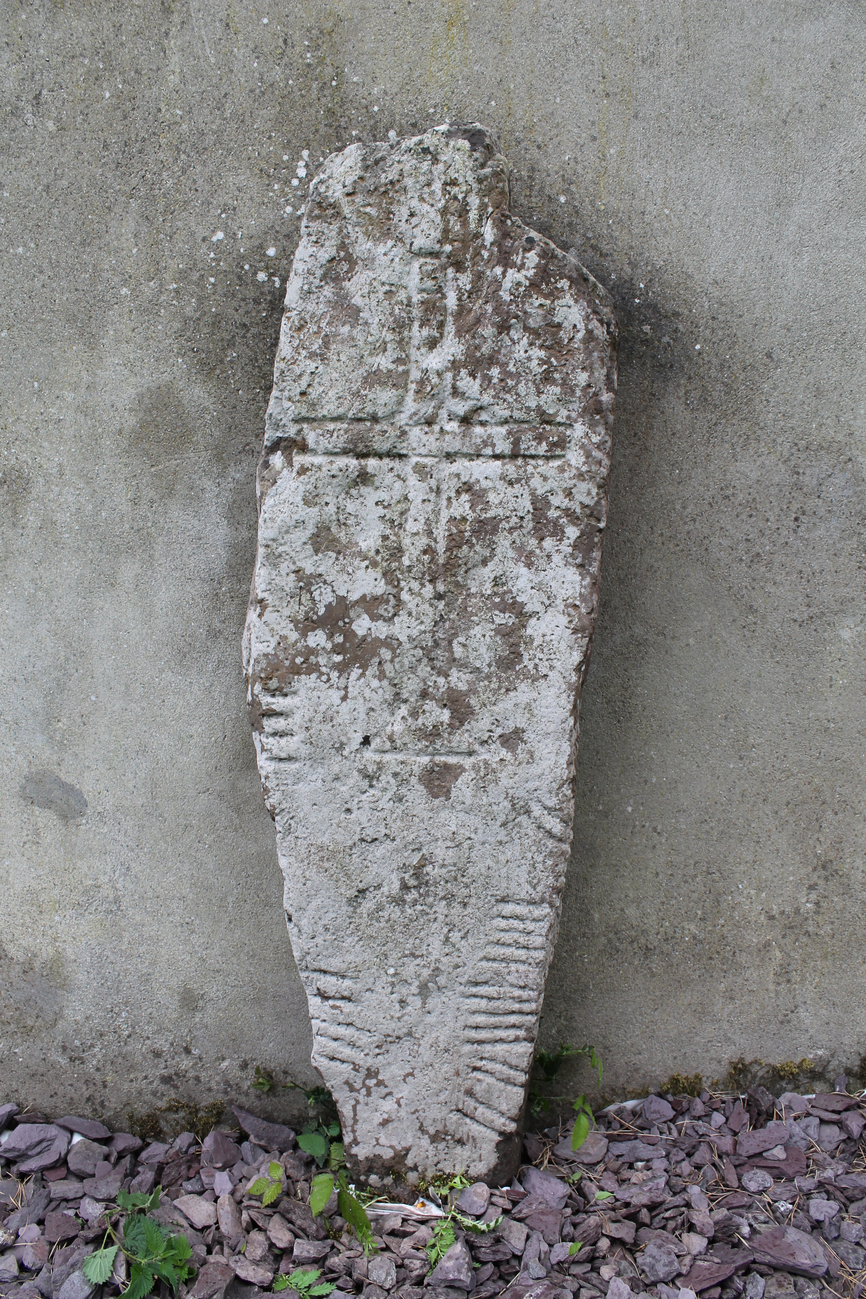
'Grit', 1.52m x 0.42m x 0.13m (Converted from Macalister 1945, 164).
'An outlined Latin cross with expanded base is carved on one face. The continuous grooves of the arms and shaft outline a square at the crossing and similar square designs are repeated at the terminals of the head and arms. The left arm has been damaged by the metal clamp which fixes the stone to the wall' (Cuppage 1986, no. 797). This metal clamp has since been removed. The cross in inverted in relation to the ogham inscription, which suggests that they are not contemporary.
Text
Up-top-down, pocked. Macalister (1945, 164-5) describes the final -I of the first name as 'spalled away'. Unfortunately, this section of the stone, which also contains the MA of MAQI, is now underground. The vowels in general are quite unclear, but the space available suggests the following.
Transliteration
Translation
Commentary
The first name here is uncertain but may be made up of the negative prefix du-/do- and an early form of a rare noun genc 'snubnose' (Ziegler 1994, 174; McManus 1991, 105). The adjective genncach 'snubnosed' seems to be later used as a nickname (eDIL s.v. genncach).
Although the vowels are uncertain, the father's name would appear (if O) to be an early form of Rúad 'Red(-haired?)' (McManus 1991, 107).
The ending -OS (and possibly originally -I in DUGENNG[I]) would suggest a possible pre-6th century date (McManus 1991, 97).
Locations
Found
found in a trench or drain close to the location marked on the OS maps (OSNB Ballinvoher, 3); this was c. 20 to 30m SE of its present position in the townland of Ballynahunt and barony of Corkaguiney.
Original
GPS coordinates of possible original location -10.002512, 52.182976
Last Recorded
Attached to the gable end of a farmhouse close to where it was discovered (GPS coordinates -10.030458, 52.181881).
History of Recording
Macalister (1945, 163) cites Petrie (1845, 136) as the first recording of the stone.
References
- Bennett I. and Uí Shíthigh B. (1995): Ogham Stones of the Dingle Peninsula. Ballyferriter, p. 24.
- Cuppage, J. et al (1986): Archaeological Survey of the Dingle Peninsula. Ballyferriter, nos. 797, 942 .
- Macalister, R.A.S. (1945): Corpus inscriptionum insularum Celticarum, pp 164-5 .
- McManus, D. (1991): A guide to ogam. Maynooth Monographs 4, pp 105, 107.
- Ziegler, S. (1994): Die Sprache der altirischen Ogam-Inschriften. Gottingen: Vandenhoeck and Ruprecht, pp 174, 227.
This work is licensed under the Creative Commons licence Attribution-NonCommercial-ShareAlike 3.0 Ireland
Copyright (c) 2013 by the School of Celtic Studies http://www.celt.dias.ie
All reuse or distribution of this work must contain somewhere a reference to http://ogham.celt.dias.ie/


