CIIC 10. Breastagh, Co. Mayo
Download Epidoc | 3D PDF | 3D OBJ | 🔗 URI https://ogham.celt.dias.ie/10._Breastagh

Site Type
Unassociated
Description
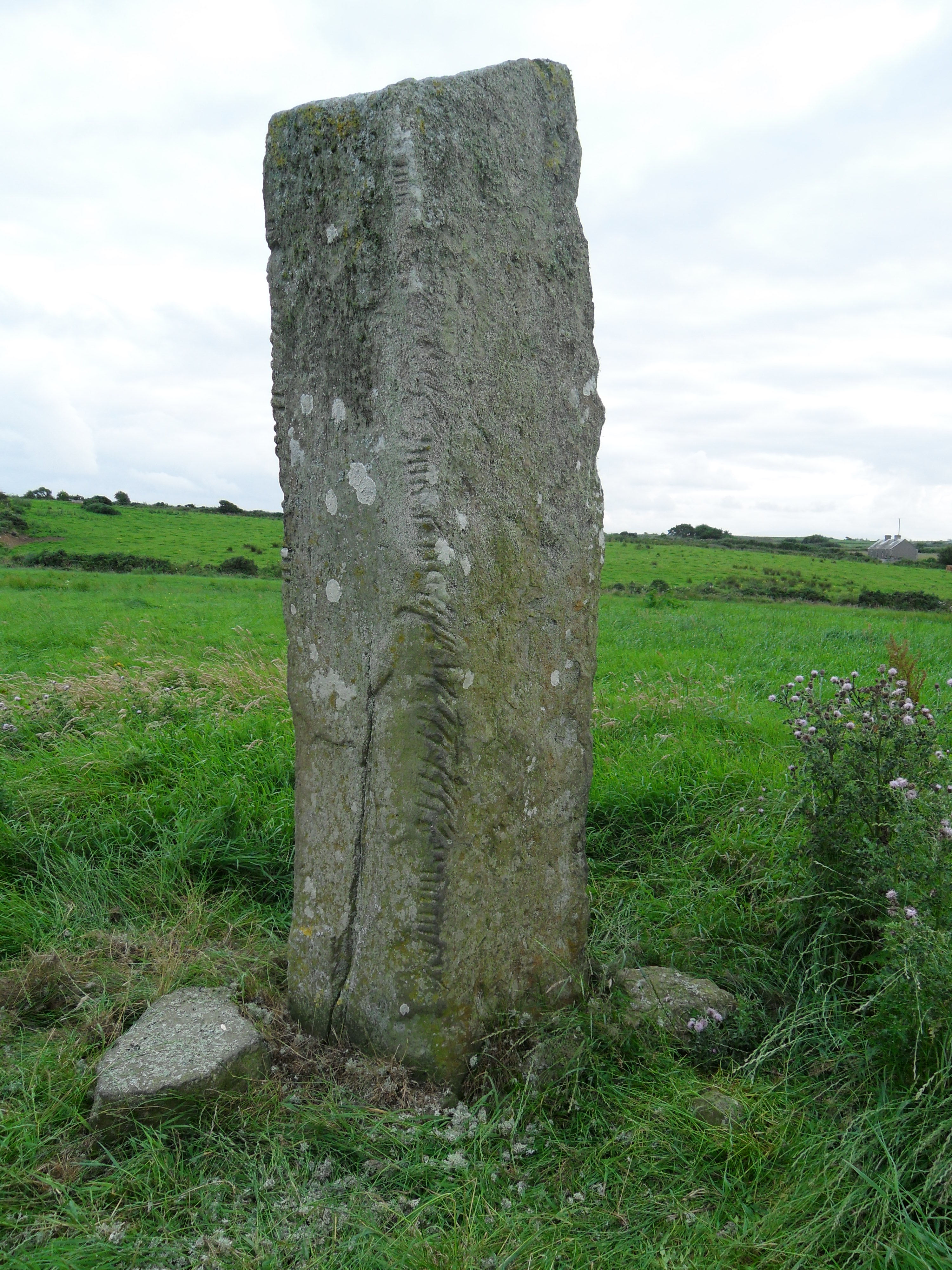
Site
A large standing stone situated in the centre of a field on farmland. Probably a pre-historic standing stone later re-used for an ogham inscription.
Monument
3.66m x 0.76m x 0.60m (converted from Macalister 1945, 13).
Text
Up/up on two the angles of the S face. 'A large flake has gone from the B-surface of the injured [dexter] angle...and nothing now appears but an L, followed by a vowel (apparently E), and after that the B-halves of two G's. A smaller, but yet more effective, fracture on the H-surface has abolished the H-halves of the G's and anything else that there might have been on that side. A battered length of angle follows, and then follows a row of fairly perfect letters, running up to the top... After several examinations of the stone, I have given up all hope of filling, even imperfectly, the long gap after the G. The gap after 1D cannot have contained anything but vowels, of which three notches remain. Having regard to the length of the space, the most likely restoration is IU. The remainder of the inscription is quite clear: the final D is, and always was, the last letter on this side, but I have no suggestion to make as to the meaning of this part on the inscription' (Macalister 1945, 13-14). The final D on this angle is no longer discernible, pesumably due to the loss of the top corner of this angle at some stage since Macalister's reading.
The right hand angle (sinister) is relatively clear for the most part. However, the top third of the stone is heavily covered in lichen obscuring much of the inscription after the LL of the second personal name. There is also what appears to be a fracture between the LL and final T, as noted by McManus (1986, 22).
Transliteration
Translation
Commentary
-
Macalister (1945, 15) suggests that 'the barony of Tirawley, where this stone stands, takes its name from the fifth-century local king Amalgaid; as Amlongad is an early form of this name, and as the king had a son,Coirpre, it is quite likely that this stone is actually a monument of a member of his family'. MacNeill (1909, 332) also, identified this name as - Amlongaid / Amolngaid, king of Connacht, who died between 440 and 450. However, McManus (1991, 53) cautions that the condition of this stone 'is such as to leave some doubt as to its reading and its language would appear to be more than two generations removed from the mid-fifth century'. Apparantly syncopated CORRB*RI (indicated by asterisk, cf. CIIC 106 CORIBIRI) would suggest a late sixth or early seventh century date (McManus 1991, 96-7).
Locations
Found
Discovered lying in a field in the townland of Breastagh and barony of Tirawley. (GPS coordinates -9.254148, 54.246617)
Original
Find location probably original site
Last Recorded
Still standing in the field. National Monuments Service Historic Environment viewer on www.archaeology.ie.
History of Recording
Discovered lying in a field in April 1874 by an English tourist, W.K. Dover, and brought to the attention of S. Ferguson, who subequently had it re-erected.
References
- Ferguson, S. (1874): 'On a Recently-Discovered Ogham Inscription at Breastagh, in the County of Mayo', PRIA 15, 201-6.
- Macalister, R. A. S. (1919): 'Notes on Some Ogham Inscriptions, including Two Recently Discovered', PRIA, 34 C, pp 400-404. JSTOR, www.jstor.org/stable/25504216
- Macalister, R.A.S. (1945): Corpus inscriptionum insularum Celticarum, pp 13-15.
- MacNeill, E. (1909): 'Notes on the distribution, history, grammar, and import of the Irish Ogham inscriptions', Proceedings of the Royal Irish Academy 27, pp 329-370.
- McManus, D. (1986): 'Ogam: archaizing, orthography and the authenticity of the manuscript key to the alphabet', Ériu 37, pp 1–31.
- McManus, D. (1991): A guide to ogam. Maynooth Monographs 4, pp 53, 96, 108, 125.
This work is licensed under the Creative Commons licence Attribution-NonCommercial-ShareAlike 3.0 Ireland
Copyright (c) 2013 by the School of Celtic Studies http://www.celt.dias.ie
All reuse or distribution of this work must contain somewhere a reference to http://ogham.celt.dias.ie/


