CIIC 151. Ballinrannig IV (BAILE AN REANNAIGH), Co. Kerry
Download Epidoc | 🔗 URI https://ogham.celt.dias.ie/151._Ballinrannig_IV

Site Type
Burial ground and probable ecclesiastical site
Description
Site
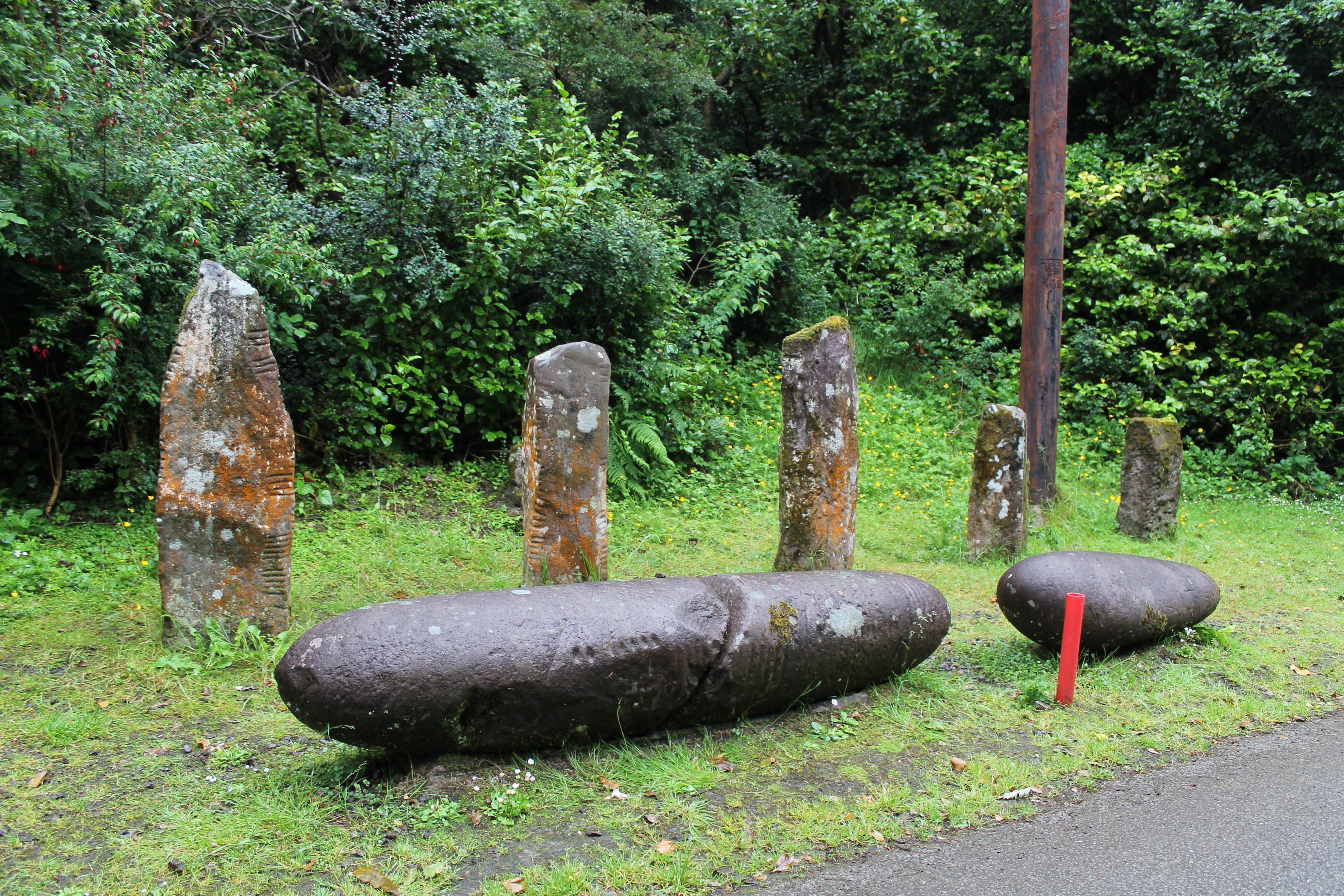
'Cillvickillane/Cill Mhic Uíleáin: A large, grass-grown, sandy knoll, crowned by a single ogham stone, is located at the base of a small promontory on the S shore of Smerwick Harbour. It was here that a storm at the end of the 18th century exposed 7 ogham stones, a possible fragment of an ogham stone, a cross-inscribed stone, a number of graves and quantities of bone, and the ruins of several houses (Windele 1838, 145; Chatterton 1839, 190). Windele's sketch of the site shows the ogham stones set out in a rough semi-circle on top of the mound with a slab-lined grave positioned nearby. Chatterton describes the houses as being beyond the mound nearer the sea. Windele interpreted these as the remains of an ancient village, but it has also been suggested that one of the structures, roughly 20 feet x 12 feet (6 x 3.7m), was a church (Curran no. 21). Lord Ventry removed 6 of the ogham stones from the site in the mid-19th century; nos. 1 to 4 now line the driveway to Burnham House/Colaiste Íde, between Dingle and Ventry, and nos. 5 and 6 are preserved in the grounds of Chute Hall near Tralee. Only no.7 is still preserved on the original site' (Cuppage 1986, 250-2).
Monument
'Slate' (Macalister 1945, 147), 0.82m x 0.26m x 0.25m (Cuppage 1986, 251). Although the top of the stone is broken on one side, the inscription appears to be complete.
Text
The inscription is pocked on one angle (up-top) and is 'in good condition' (Macalister 1945, 147).
Transliteration
Translation
Locations
Found
Exposed by a storm at the end of the 18th century, along with 6 other ogham stones (Cuppage 1986, 250), in the townland of Ballinrannig and barony of Corkaguiney. (GPS coordinates -10.388106, 52.178511)
Original
Find location probably original site
Last Recorded
In the mid 19th century this stone and CIIC 151 were moved by Lord Ventry to the grounds of Burnham House (now Coláiste Íde), between Dingle and Ventry, where they remain today. The present location of this stone may be accessed via the National Monuments Service Historic Environment viewer on www.archaeology.ie. (GPS coordinates-10.306267, 52.126711)
History of Recording
First recognised in 1782 by Pelham and recorded by Vallancey (1804) in Collectanea de Rebus Hibernicis 6, 226 (Macalister 1945, 144). This stone was recorded for the Ogham in 3D project in 2017 by Orla Breslin, a participant on the Corca Dhuibhne 3d project, using Structure from Motion 3d technology.
References
- Bennett I. and Uí Shíthigh B. (1995): Ogham Stones of the Dingle Peninsula. Ballyferriter, pp 7-8.
- Cuppage, J. et al (1986): Archaeological Survey of the Dingle Peninsula. Ballyferriter, pp 250-1.
- Macalister, R.A.S. (1945): Corpus inscriptionum insularum Celticarum, pp 144, 147.
- McManus, D. (1991): A guide to ogam. Maynooth Monographs 4, pp 65, 116.
Websites and Online Databases
- Corca Dhuibhne 3d: www.corcadhuibhne3d.ie
- Gippert, J. (2001): Thesaurus Indogermanischer Text-und Sprachmateriale. TITUS OGAMICA. (3rd edition) University of Frankfurt: titus.fkidg1.uni-frankfurt.de/ogam/frame
- CISP (Celtic Inscribed Stones Project): www.ucl.ac.uk/archaeology/cisp/database/
- MacShamhráin, A.: Monasticon Hibernicum database - Early Christian Ecclesiastical Settlement in Ireland 5th to 12th Centuries: monasticon.celt.dias.ie
This work is licensed under the Creative Commons licence Attribution-NonCommercial-ShareAlike 3.0 Ireland
Copyright (c) 2013 by the School of Celtic Studies http://www.celt.dias.ie
All reuse or distribution of this work must contain somewhere a reference to http://ogham.celt.dias.ie/


