CIIC 198. Coolmagort II, Co. Kerry
Download Epidoc | 3D PDF | 3D OBJ | 🔗 URI https://ogham.celt.dias.ie/198._Coolmagort_II


Site Type
Souterrain
Description
Site
This souterrain (KE065-078----), marked ‘Cave’ on the OS maps, was discovered in 1838 by workmen building a field boundary across a slight rise in Dunloe Castle demesne, a short distance W of the River Loe. A total of seven ogham stones were incorporated into its structure. Atkinson and Romilly Allen visited it individually several decades later, and recorded that the accessible section of its passage was c. 5.7m in overall length and averaged l.3m in height (1866, 523-4; 1892, 166-70). Access was gained through an opening at S, where the passage was 7 feet (2.15m) wide. From here it curved to NE, decreasing in width to 3 feet 3 inches (1m). The walls were of drystone construction and inclined slightly to reduce the passage width at roof level. It was roofed by nine slabs, six of which bore ogham inscriptions. One of the larger ogham stones had cracked in antiquity and was supported by a seventh, which stood upright in the souterrain passage. A number of bones and skulls, some of which were reputedly human, were found in the souterrain. In 1940 the ogham stones were removed from the site by the OPW, and were erected close to a public roadway nearby. The souterrain was subsequently filled back and no surface trace remains (Extract from ASI database, www.archaeology.ie).
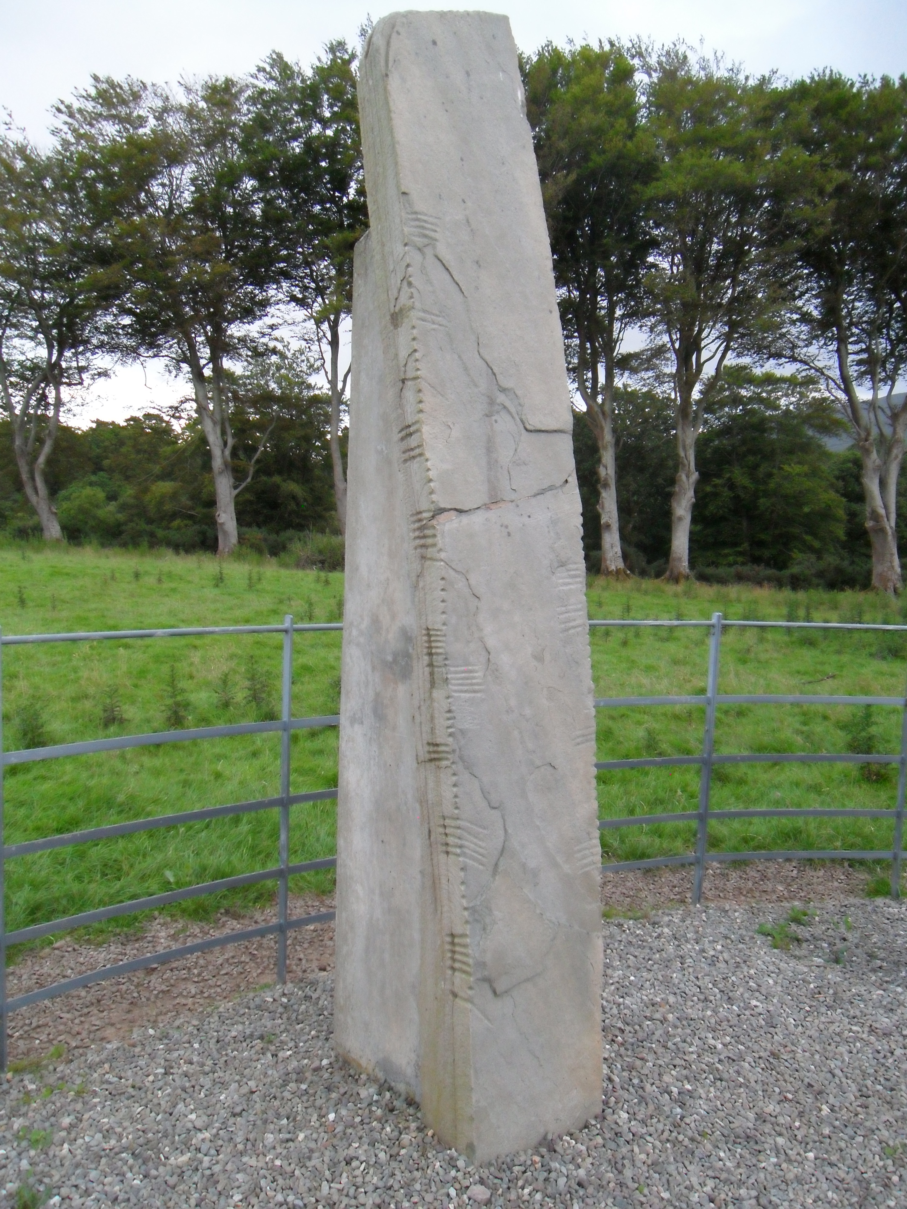
Monument
2.65m x 0.48m x 0.20m (O'Sullivan et al 1996, no. 863 (2)). This was 'the second lintel from the entrance' in the souterrain and was fractured towards the centre when in situ and supported by an upright stone beneath CIIC 199 (Brash 1879, 232).
Text
'Inscribed on two angles (up-up) with beautiful neatness... Adjacent to 1S there is a pocked rectangular space on the H-surface' interpreted by Macalister (1945, 193) as indicating the removal of an erroneous character. As pointed out by McManus (1991, 65), it would appear that 'an S inserted prematurely at the first E was erased by the lapidary'. Although Gippert appears to take these as one and the same correction, an examination of the 3d data and detailed photographs of this stone confirms that there are two cases of erasures present: Macalister's, as he states himself, on the H-surface 'adjacent' to the S and McManus' on the B-surface beside at the E and beneath the S. This suggests that the lapidary had gone further than the S before he realised his mistake. The H-surface erasure may have been to remove a premature start to MAQI.
Transliteration
Translation
Commentary
-
As noted by others, including McManus (1991, 53, 112), three of the seven stones at this site appear to commemorate members of the kin group of *Toicacas (see also TOICAKI on CIIC 197 and TOICAC on CIIC 200). This name has been equated by MacNeill (1911, 69, n.1.) with the population known as Tóecraige.
-
Mahon (1990, 13) has convincingly suggested an identification for three of the names of the descendants of *Toicacas occurring on both this stone and on CIIC 197 to be found 'at the head of the Rawlinson B.502 genealogy for the Glasraige'.
-
The personal name MAQI-RITEAS occurs in a later form (MAQI-RITE) at Rockfield (Co. Kerry, CIIC 243). The Gurrane stone (Co. Kerry, CIIC 252) appears to have the second element, DUMELI, of the other personal name here (McManus 1991, 180, n.50).
-
Vowel affection is present here with -EAS for -IAS in both personal names. This indicates a date of approximately the end of the 5th century (McManus 1991, 94, 97, 115). However, it should also be taken into consideration that there is evidence for a corrected error here at the -EAS of -RITEAS, which may indicate that the process of apocope had already begun, as in the case of CIIC 197.
Locations
Found
along with six other ogham stones in a souterrain known as 'the cave of Dunloe' in the townland of Coolmagort and barony of Dunkerron North (GPS coordinates -9.633466, 52.060741).
Original
Unknown
Last Recorded
In a small modern enclosure (together with CIIC 241 Kilbonane) near the entrance to the Gap of Dunloe, close to where originally found. The present location of this stone may be accessed via the National Monuments Service Historic Environment viewer on www.archaeology.ie. (GPS coordinates -9.634923, 52.06042)
History of Recording
discovered in 1838 by workmen building a field boundary. Gippert: The site was first visited by `Mr. Abell, of Cork' who `on that occasion took copies of such of the inscriptions as were then accessible'. After that, it was inspected by J. Windele `and a party of antiquaries from Cork'; Brash saw the spot in the autumn of 1869.
References
- Brash R. R. (1879): The Ogam Inscribed Monuments of the Gaedhil in the British Isles, p. 232.
- Macalister, R.A.S. (1945): Corpus inscriptionum insularum Celticarum, pp 191-3.
- MacNeill, E. (1911): 'Early Irish population groups', Proceedings of the Royal Irish Academy 29, p. 69, n.1..
- Mahon, W. (1990): 'Glasraige, Tóecraige, and Araid: evidence from Ogam', Proceedings of the Harvard Celtic Colloquium) 8, pp 11–30.
- McManus, D. (1991): A guide to ogam. Maynooth Monographs 4, pp 53, 65, 79, 94, 109, 115.
- O'Sullivan, A. and Sheehan, J.(1996): The Iveragh Peninsula: An Archaeological Survey of South Kerry. Cork, no. 863.
This work is licensed under the Creative Commons licence Attribution-NonCommercial-ShareAlike 3.0 Ireland
Copyright (c) 2013 by the School of Celtic Studies http://www.celt.dias.ie
All reuse or distribution of this work must contain somewhere a reference to http://ogham.celt.dias.ie/


