CIIC 253. Killorglin, Co. Kerry.
Download Epidoc | 3D PDF | 3D OBJ | 🔗 URI https://ogham.celt.dias.ie/253._Killorglin

Site Type
Souterrain
Description
Site
Souterrain ('rath cave') in the vicinity of Killorglin is all that is known of the original site (O'Sullivan et al 1996, 244).
Monument
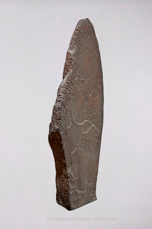
1.2m x 0.45m x 0.42m (O'Sullivan et al 1996, 244).
Text
Vertical, Up. In addition to the clear inscription transcribed below, 'Macalister noted three vowel strokes near the top of the stone which, he suggested, represent the end of an earlier inscription. It seems equally possible, however, that they are a continuation of this inscription (information: F. Moore)' (O'Sullivan et al 1996, 244).
Locations
Found
in a souterrain somewhere near Killorglin (Macalister 1947, 247) in the barony of Trughanacmy. Precise coordinates unknown. (GPS coordinates, approximate location only -9.778697, 52.106495)
Original
Unknown
Last Recorded
National Museum of Ireland (NMI Ref. 1885:431), Dublin. The present location of this stone may be accessed via the National Monuments Service Historic Environment viewer on www.archaeology.ie. (GPS coordinates -6.254558,53.340408)
Recording
first mentioned in 1877 by Graves, C. (Macalister 1947, 247).
References
- Macalister, R.A.S. (1945): Corpus inscriptionum insularum Celticarum, pp 247-8.
- McManus, D. (1991): A guide to Ogam. Maynooth Monographs 4, p. 65.
- O'Sullivan, A. and Sheehan, J.(1996): The Iveragh Peninsula: An Archaeological Survey of South Kerry. Cork, p 244.
- Rhys, J. (1902): 'The ogham-inscribed stones of the Royal Irish Academy and of Trinity College Dublin', JRSAI, Vol. 32, pp 1-41.
This work is licensed under the Creative Commons licence Attribution-NonCommercial-ShareAlike 3.0 Ireland
Copyright (c) 2013 by the School of Celtic Studies http://www.celt.dias.ie
All reuse or distribution of this work must contain somewhere a reference to http://ogham.celt.dias.ie/


