CIIC 48. Donard, Co. Wicklow
Download Epidoc | 3D PDF | 3D OBJ | 🔗 URI https://ogham.celt.dias.ie/48._Donard

Site Type
Standing stone pair
Description
Site
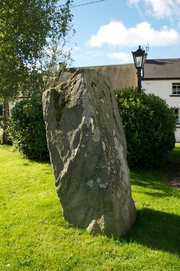
'Formerly standing beside another stone (at a distance of 1' 6"), uninscribed, on the farm called Old Mills, south of the village of Donard '(Macalister 1945, 52); (Corlett and Weaver 2002, 541). With permission of the landowner, we visited the original site in September 2010 on a scanning trip to the area. It is located at the top of a slope in the south corner of a field south of the farmhouse in the townland of Ballylion Lower. The remaining stone has no visible inscription and is approximately 1.37m high.
Monument
'Rectangular block of stone', 1.52m x 0.69m x 0.53m (converted from Macalister 1945, 52).
Text
up-top 'dexter angle of main face... The first Q is flaked, and the C is practically worn away' (Macalister 1945, 52) 'The inscription is much worn and damaged... After it turns on to the top [after KOI] nothing definite can be stated about the inscription' (Macalister 1897, 77).
Commentary
The personal name here may be formed from iach, gen. of éo 'salmon', plus a diminutive suffix (Ziegler 1994, 186). Hypercorrect Q for C is also found, for example, in CIIC 40. INEQAGLAS (Enechglas) (McManus 1991, 121-2).
'KOI, which is invariably written with the first supplementary character and is alone among formula words in not being attested later, has been explained as a word defining locality, 'here', analogous to HIC IACIT in the British inscriptions though it is never used in these ' (McManus 1991, 119).
cf. CIIC 22. Colbinstown IV: EGNI KOI MAQI MUC[ ... ].
Locations
Found
Discovered standing beside another (uninscribed) stone on a farm called 'Old Mills', south of the village of Donard (Macalister 1945, 52; Corlett and Weaver 2002, 541), in townland of Ballylion Lower and barony of Lower Talbotstown. The find location of this stone may be accessed via the National Monuments Service Historic Environment viewer on www.archaeology.ie. (GPS: -6.633596,53.009083)
Original
Find location possibly original site
Last recorded
Located on the village green since 1995, having had three previous locations. The present location of this stone may be accessed via the National Monuments Service Historic Environment viewer on www.archaeology.ie. (GPS: -6.613237,53.021622)
History of Recording
Published by Rhys (1903, 113) where he referred to it as 'The Oldmills Piper Stone'.
References
- Rhys, J. (1903): 'Notes on ogam inscriptions-1. The Oldmills Piper Stone, County Wicklow. 2. The Carncomb Ogam, Connor, County Antrim', JRSAI 33, pp 113-8.
- Macalister, R.A.S. (1897): Studies in Irish Epigraphy. A Collection of Revised Readings of the Ancient Inscriptions of Ireland, with Introduction and Notes. Part 1. London: David Nutt, pp 66-7.
- Macalister, R.A.S. (1945): Corpus inscriptionum insularum Celticarum, p.52.
- Corlett, C. and Weaver, M.(eds) (2002): The Price Notebooks, Vol. 2, p.541.
- Grogan, E. and Kilfeather, A. (1997): Archaeological Inventory of County Wicklow. Dublin, p. 160.
- Ziegler, S. (1994): Die Sprache der altirischen Ogam-Inschriften. Gottingen: Vandenhoeck and Ruprecht.
Websites and Online Databases
- CISP (Celtic Inscribed Stones Project): www.ucl.ac.uk/archaeology/cisp/database/
- National Folklore Collection UCD Digitization Project: The Schools Collection (1937-38): https://www.duchas.ie
- Gippert, J. (2001): Thesaurus Indogermanischer Text-und Sprachmateriale. TITUS OGAMICA. (3rd edition) University of Frankfurt: titus.fkidg1.uni-frankfurt.de/ogam/frame
This work is licensed under the Creative Commons licence Attribution-NonCommercial-ShareAlike 3.0 Ireland
Copyright (c) 2013 by the School of Celtic Studies http://www.celt.dias.ie
All reuse or distribution of this work must contain somewhere a reference to http://ogham.celt.dias.ie/


